Introduction to Angles and Mapping
Please note: The spring 2024 session has been canceled. Information about future sessions will be posted as it becomes available.
About the Course
This hybrid course introduces students to angles and direction (including bearings and azimuth) and coordinate geometry calculations.
The online portion of the course will describe the equipment, procedure, and note-taking required to conduct both a simple traverse with corrections and collect topographic survey data. Then, at an in-person field lab workshop, students will collect data and complete a simple exercise to manually transfer mapping notes to paper format.
Course Requirements
Students must complete the required online coursework prior to the field lab workshop.
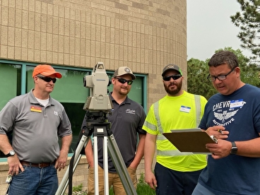
All students will need to use their own (agency-supplied) survey equipment and must bring the following to the in-person field lab workshop:
- Total station
- Charged batteries
- Tripod
- Tribrach
- Prism
- Survey rod
Course Objectives
After completing this course, students will be able to:
- Set up a survey tripod
- Operate a total station
- Manually record and reduce traverse notes
- Manually record and reduce mapping notes
- Manually transfer mapping notes to paper format
Who Should Attend
This course is meant for public agency personnel or anyone interested in learning the basics of land surveying and differential leveling. It is designed for anyone who performs civil design data collection or uses the information in their job. The techniques covered are applicable for field data collection for roadway or civil design, or for verification in the field during construction.
Course Instructors
Eric Johnson has most recently worked as a construction inspector for Professional Engineering Services. Over the last 20 years, Eric has served as an inspector on many local municipal projects, including the Guthrie Theater, Target Field, Highway 212, the Central Corridor and Southwest Corridor Light Rail projects, the 35E MnPASS project, Highway 610, various Metropolitan Council sewer rehab projects, and the Saint Paul Metro Wastewater Treatment Plant renovation. He carries multiple MnDOT inspection certifications as well as the national CIPP inspection certification through NASSCO. Eric is a 1993 graduate of the University of Wisconsin−Eau Claire with a BA in secondary English education.
Ted Johnson has taught classes for MnDOT as part of ADA training and in the MnDOT Technical Certification Program. He’s worked extensively for MnDOT for the last 15 years and is currently a grading inspector on the Highway 14 Expansion Design Build. Ted spent the first part of his career as a high school teacher, teaching art and industrial education. He has a degree in secondary education.
Online Coursework Access and Technical Requirements
A portion of this training is offered via the course management system Canvas. Upon completing your online registration, you will receive an email confirmation. To access the course, please visit Canvas and log in with your University of Minnesota internet ID and password. Once you have been enrolled, your course will appear on your Canvas dashboard.
If for any reason you do not have access to the course after enrolling, please contact Katherine Stanley at sell0146@umn.edu for assistance.
Because it's built using web standards, Canvas runs on Windows, Mac, Linux, iOS, Android, or any other device with a modern web browser. Chrome, Firefox, Safari, and Internet Explorer work best for this course.
Credit
- 1.0 Roads Scholar Program Civil Tech Level I Certificate credit.
- To the best of our knowledge, this course meets the continuing education requirements for 13.0 Professional Development Hours (PDHs). Learn more about continuing education for professionals from the Minnesota Board of AELSLAGID.
Sponsors
This workshop is presented by Minnesota LTAP at the Center for Transportation Studies, University of Minnesota. Minnesota LTAP is sponsored by the Minnesota Local Road Research Board (LRRB) and the Federal Highway Administration (FHWA). This course is subsidized through funding from LRRB and FHWA.